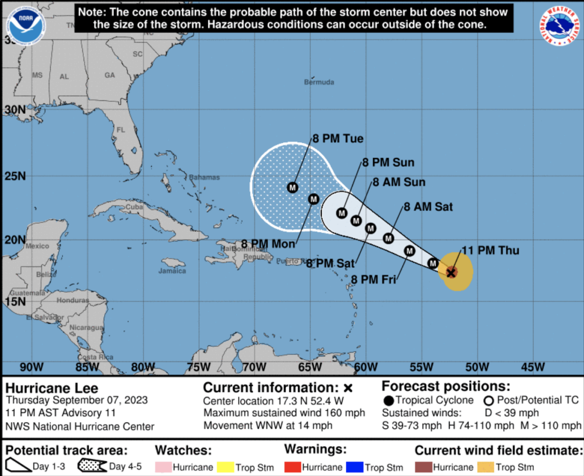
Hurricane Lee has become a “dangerous” Category 5 storm over the Atlantic Ocean, the National Hurricane Center (NHC) announced late Thursday.
An Air Force Reserve Hurricane Hunter found that the hurricane “skyrocketed” to the high end of the Saffir-Simpson Hurricane Wind Scale during the day with sustained maximum winds of 160 miles per hour, the federal agency explained in an 11 p.m. ET discussion post.
The storm is expected to maintain a “steady” track to the west-northwest, passing “well to the north” of the northern Leeward Islands, the Virgin Islands, and Puerto Rico over the next five days, NHC said.
During that period, Lee may slightly diminish to Category 4 status, which would still keep it as a major hurricane with the potential for “catastrophic” damage, according to the Saffir-Simpson Hurricane Wind Scale.
Lee, now a category five hurricane with winds of 160 mph, is still expected to turn north before reaching the U.S. East Coast next week. pic.twitter.com/wRk5uHo5YR
— James Spann (@spann) September 8, 2023
Afterward, the track for Hurricane Lee becomes far less certain, as is often the case with extended forecasts.
“Although there are some indications that Lee might begin a northward turn around the middle of next week, it is still way [too] soon to focus on specific model scenarios that far out into the future,” NHC said.
Some computer models indicated on Thursday that Hurricane Lee could threaten to directly impact, if not make landfall, over the Mid-Atlantic, New England, or Canada. Another possibility is that the storm gets steered away from the U.S.
#BREAKING: CATEGORY 5 HURRICANE #LEE. 160 MPH WINDS. #TropicalUpdate 🌀 pic.twitter.com/wN6wIOU8K6
— Dylan Federico (@DylanFedericoWX) September 8, 2023
“Dangerous surf and life-threatening rip currents are likely in the northern Leeward Islands beginning Friday. These conditions will spread westward and northward, affecting Puerto Rico, Hispaniola, the Turks and Caicos, the Bahamas, and Bermuda through the weekend,” the NHC said as one of its “key messages” in its 11 p.m. post.
“It is way too soon to know what level of impacts, if any, Lee might have along the U.S. East Coast, Atlantic Canada, or Bermuda late next week, particularly since the hurricane is expected to slow down considerably over the southwestern Atlantic,” NHC said in another message. “Regardless, dangerous surf and rip currents are expected along most of the U.S. East Coast beginning Sunday. Continue to monitor updates to Lee’s forecast during the next several days.”
The Weather Channel also emphasized the uncertainty in the longterm forecast, but warned “Bermuda, the northeast U.S. coast and Atlantic Canada should monitor the forecast closely.”
CLICK HERE TO GET THE DAILY WIRE APP
The Atlantic hurricane season, which stretches from June 1 to November 30, is currently at its peak. Lee is the first Category 5 hurricane since last season. Tropical Storm Margot has formed over the eastern Atlantic Ocean, and so far the NHC forecast calls for it stay out to sea as it becomes a hurricane.
Another hurricane named Idalia slammed into Florida’s Gulf Coast last week, causing flooding, power outages, and at least two deaths.

